Mojave Desert
| Mojave Desert (Hayikwiir Mat'aar [1] in Mojave) | |
| Desert | |
| Country | United States |
|---|---|
| States | California, Nevada, Utah, Arizona |
| Part of | North American Desert ecoregion[1] |
| Borders on | Great Basin Desert (north) Sonoran Desert (south) Colorado Plateau (east) Colorado Desert (south) |
| River | Mojave River |
| Coordinates | |
| Lowest point | Badwater Basin -282 ft (ã86.0 m)) |
| - location | Death Valley[2] |
| - coordinates | |
| Area | 25,000 sq mi (64,750 kmôý) |
| Geology | Basin and Range Province |
| For public | Mojave National Preserve, National Parks (Death Valley, Joshua Tree, Zion, and Grand Canyon) |
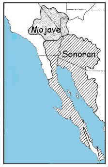 Alternate Mojave depiction with Sonoran Desert
|
|
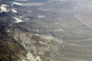
The Mojave Desert (pronounced /moòùhèùvi/ or /mèùhèùvi/, or High Desert) occupies a significant portion of southeastern California and smaller parts of central California, southern Nevada, southwestern Utah and northwestern Arizona, in the United States. Named after the Mohave tribe of Native Americans, it is a typical Basin and Range topography.
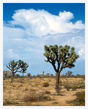
The Mojave Desert's boundaries are generally defined by the presence of Yucca brevifolia (Joshua trees); considered an indicator species for this desert. The topographical boundaries include the Tehachapi together with the San Gabriel and San Bernardino mountain ranges. The mountain boundaries are quite distinct since they are outlined by the two largest faults in California: the San Andreas and the Garlock. The Great Basin shrub steppe lies to the north; the warmer Sonoran Desert (the Low Desert) lies to the south and east. The desert is believed to support between 1,750 and 2,000 species of plants.[3]
Contents |
Climate
The Mojave Desert receives less than 10 inches (254 mm) of rain a year and is generally between 3,000 and 6,000 feet (1,000 and 2,000 m) in elevation. The Mojave Desert also contains the Mojave National Preserve, as well as the lowest and hottest place in North America: Death Valley, where the temperature normally surpasses 120ô¯F (49ô¯C) in late July and early August. Zion National Park, in Utah, lies at the junction of the Mojave, the Great Basin Desert, and the Colorado Plateau. Despite its aridity, the Mojave (and particularly the Antelope Valley in its southwest) has long been a center of alfalfa production, fed by irrigation coming from groundwater and (in the 20th century) from the California Aqueduct.
The Mojave is a desert of temperature extremes and four distinct seasons. Winter months bring temperatures dipping to below 20 ô¯F (-7 ô¯C) on valley floors, and below 0 ô¯F (-18 ô¯C) at higher elevations. Storms moving from the Pacific Northwest can bring rain and snow across the region ã more often, the rain shadow created by the Sierra Nevada as well as mountain ranges within the desert such as the Spring Mountains bring only clouds and wind. In longer periods between storm systems, winter temperatures in valleys can approach 80 ô¯F (27 ô¯C).
Spring weather continues to be influenced by Pacific storms, but rainfall is more widespread and occurs less frequently after April. By early June, it is rare for another Pacific storm to have a significant impact on the region's weather, and temperatures after mid-May are normally above 90 ô¯F (32 ô¯C) and frequently above 100 ô¯F (38 ô¯C).
Summer weather is dominated by heat ã temperatures on valley floors can soar above 120 ô¯F (49 ô¯C) and above 130 ô¯F (54 ô¯C) at the lowest elevations ã and the presence of the North American monsoon. Low humidity, high temperatures and low pressure draw in moisture from the Gulf of Mexico, creating thunderstorms across the desert southwest. While the Mojave does not get nearly the amount of rainfall that the Sonoran desert to the east receives, monsoonal moisture will create thunderstorms as far west as California's Central Valley from mid-June through early September.
Autumns are generally pleasant, with one to two Pacific storm systems creating regional rain events. October is one of the driest and sunniest months in the Mojave, and temperatures usually remain between 70 ô¯F (21 ô¯C) and 90 ô¯F (32 ô¯C) on the valley floors.
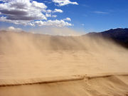
After temperature, wind is the most significant weather phenomenon in the Mojave. Across the region, windy days are common, and in areas near the transition between the Mojave and the California low valleys, including near Cajon Pass, Soledad Canyon and the Tehachapi areas. During the June Gloom, cooler air can be pushed out into the desert from Southern California; in Santa Ana wind events, hot air from the desert blows out into the Los Angeles basin and other coastal areas. Wind farms in these areas generate power from these winds.
The other major weather factor in the region is elevation. The highest peak within the Mojave is Charleston Peak at 11,918 feet (3,633 m),[4] while Badwater in Death Valley is 282 feet (86 m) below sea level. Accordingly, temperatures and precipitation ranges wildly, in all seasons, across the region.
The Mojave Desert has not historically supported a fire regime because of low fuel loads and connectivity. However, in the last few decades, invasive annual plants (e.g., Bromus spp., Schismus spp., Brassica spp.) have facilitated fire, which has significantly altered many areas of the desert. At higher elevations, fire regimes are regular but infrequent.
Cities and regions
While the Mojave Desert itself is sparsely populated, it has increasingly become urbanized in recent years. Las Vegas, Nevada is the largest city in the Mojave, with a metropolitan population of around 1.9 million in 2006. Palmdale is the largest California city in the desert, and over 850,000 people live in areas of the Mojave attached to the Greater Los Angeles metropolitan area, including Palmdale and Lancaster (referred to as the Antelope Valley); and Victorville, Apple Valley and Hesperia (referred to as the Victor Valley) attached to the Inland Empire metropolitan area, the 14th largest in the nation. Smaller cities in the Mojave include St. George; Lake Havasu City; Kingman; Laughlin; Bullhead City; and Pahrump. All have experienced rapid population growth since 1990.
Towns with fewer than 30,000 people in the Mojave include Barstow, California; Rosamond, California; Needles, California; Nipton, California; Ridgecrest, California; Mesquite, Nevada; Hurricane, Utah; Moapa Valley, Nevada; California City, California; Twentynine Palms, California; Joshua Tree, California; Pioneertown, California; Lone Pine, California; and Mojave, California. The California portion of the desert also contains Edwards Air Force Base, the home of several past and current experimental aviation projects for the United States military.
The Mojave Desert contains a number of ghost towns, the most significant of these being the gold-mining town of Oatman, Arizona, the silver-mining town of Calico, California, and the old railroad depot of Kelso. Some of the other ghost towns are of the more modern variety, created when U.S. Route 66 (and the lesser-known US Highway 91) were abandoned in favor of the Interstates. The Mojave Desert is crossed by major highways Interstate 15, Interstate 40, US Highway 395 and US Highway 95.
Other than the Colorado River on the eastern half of the Mojave, few long streams cross the desert. The Mojave River is an important source of water for the southern parts of the desert. The Amargosa River flows from the Great Basin Desert south to near Beatty, Nevada, then underground through Ash Meadows before returning to the surface near Shoshone, California and ending in Death Valley.
The Mojave Desert is also home to the Devils Playground, about 40 miles of dunes and salt flats going in a northwest-southeasterly direction. The Devils Playground is a part of the Mojave National Preserve and is located between the town of Baker, California and Providence Mountains. The Cronese Mountains are found within the Devils Playground.
Parks and tourism
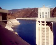
The Mojave Desert is one of the most popular tourism spots in North America, primarily because of the gambling destination of Las Vegas, Nevada. The Mojave is also known for its scenic beauty, with three national parks ã Death Valley National Park, Joshua Tree National Park, and the Mojave National Preserve. Lakes Mead, Mohave, and Havasu provide water sports recreation, and vast off-road areas entice off-road enthusiasts. Hoover Dam is a popular tourist destination. Visitors get a chance to see the structure, the hydroelectric power plant, and hear the history of the dam's construction during the Great Depression.[5]
Besides the major national parks there are other areas of identified significance and tourist interest in the desert such as the Big Morongo Canyon Preserve, which spans the Mojave and Colorado Desert, and the Red Rock Canyon National Conservation Area, 17 miles (27 km) west of Las Vegas, both of which are managed by the Bureau of Land Management. The BLM also administers Rainbow Basin and Owl Canyon, two off-the-beaten-path scenic attractions north of Barstow.
Among the more popular and unique tourist attractions in the Mojave is the self described world's tallest thermometer at 134 feet (41 m) high, which is located along Interstate 15 in Baker, California. The newly-renovated Kelso Depot and the massive Kelso Dunes in the nearby Mojave National Preserve are also popular recreation spots. Calico Ghost Town, in Yermo, is administered by San Bernardino County. The pseudo-authentic ghost town has several shops and attractions, and is said to have inspired Walter Knott to build Knott's Berry Farm. Nipton, California, located on the northern entrance to the Mojave National Preserve, is a restored ghost town founded in 1885.
The Calico Early Man Site, in the Calico Hills east of Yermo, is believed by some archaeologists, including the late Louis Leakey, to show the earliest evidence of human activity in North America. Most archaeologists dismiss the so-called tools found here as geofacts.
A tour of the Mojave Desert inspired American songwriter Carrie Jacobs-Bond to compose the parlor song "A Perfect Day" in 1909.[6] In Don't Shoot Me Santa a song by The Killers the Mojave Desert is metioned.
West Mojave Plan Litigation
The U.S. Bureau of Land Management (BLM), which manages public lands in the Mojave Desert as part of its National Landscape Conservation System, has designated numerous large off-road vehicle open use areas on public lands in the western Mojave Desert, including El Mirage, Jawbone, Rasor, Spangler Hills, Stoddard Valley, Dove Spring Canyon, Dumont Dunes, and the world's largest open off-road vehicle use area, Johnson Valley. Open areas designated for unrestricted vehicle travel in the western Mojave Desert total 363,480 acres. Several additional open areas dedicated to unrestricted vehicle travel on public lands have been designated in the northern and eastern Colorado (NECO) Desert. In 2002, BLM designated all washes in the southeastern third of the NECO planning area as also open to unrestricted vehicle travel. This was followed in 2003 by BLM expanding the off-road vehicle network in the western Mojave Desert to enhance off-road vehicle recreation opportunity. In 2004, relative to the case of Center for Biological Diversity, et al., Plaintiffs, v. Bureau of Land Management, et al., Defendants; the United States District court enjoined "all off-road vehicle use in the washes of the NECO Desert planning area pending issuance of a new biological opinion."[7]:a. A new biological opinion was subsequently issued and BLM's open wash designation in the NECO planning area was reinstated. In 2006, several environmental groups protested an additional route network expansion designated under the West Mojave Desert (WEMO) plan.
In 2009, U.S. District Judge Susan Illston ruled against the BLM's proposed designation of additional off-road-vehicle use allowance in the western Mojave Desert. According to the ruling, the BLM violated its own regulations[8] when it designated approximately 5,000 miles of off-roading routes in 2006.[9] According to Judge Ilston, the BLM's designation was significantly "flawed because it does not contain a reasonable range of alternatives" to limit damage to sensitive habitat.[10] Judge Illston found that the bureau had inadequately analyzed the routes' impacts on air quality, soils, plant communities, riparian habitats, and sensitive species such as the endangered Mojave fringe-toed lizard, pointing out that the desert and its resources are "extremely fragile, easily scarred, and slowly healed."[10]
The court also found that the BLM failed to follow route designation procedures established in the agencyãs own California Desert Conservation Area Plan, which allowed visitors to create hundreds of illegal OHV routes during the past three decades. The plan normally requires the BLM to consider the impacts to private property, non-motorized recreation opportunity, and natural resources before establishing off road areas.[8] The adopted West Mojave plan amendment was found to have violated the BLM's own manual of regulations, the Federal Land Policy and Management Act of 1976 (FLPMA) and the National Environmental Policy Act of 1969 (NEPA).[9] The ruling was considered a success for a coalition of conservation groups, including the Friends of Juniper Flats, the Alliance for Responsible Recreation, California Off-road Vehicle Watch, The Center for Biological Diversity, The Sierra Club, and The Wilderness Society, who together initiated the legal challenge in late 2006.[10]
Native Mojave plants and animals

Plants
- Abies concolor
- Astragalus newberryi
- Barrel Cactus
- Banana yucca
- Beaver Tail Prickly Pear
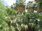
- California Fan Palm
- Camissonia campestris Mojave suncup
- Cooper dyssodia
- Death Valley monkeyflower
- Desert candle
- Desert five-spot
- Desert larkspur
- Desert Lily
- Desert rock pea
- Desert star
- Erigeron concinnus
- Ipomopsis arizonica
- Joshua Tree[11]
- Jumping Cholla
- Larrea tridentata
- Linanthus demissus
- Lupinus arizonicus
- Mojave prickly poppy
- Mojave sage[12]
- Mojave yucca[12]
- Mormon Tea
- Pencil Cholla
- Phacelia calthifolia
- Phacelia crenulata
- Pinus monophylla
- Prairie clover
- Senna covesii
- Teddy-bear Cholla[12]
- Utah Juniper
- Western poison oak[13]
- White woolly daisy
- Wide-bannered lupine
Animals
- California Kingsnake
- Chuckwalla
- Common Side-blotched Lizard
- Long-tailed Brush Lizard
- Cottontail rabbit
- Cougar
- Coyote
- Desert Bighorn Sheep
- Desert Chipmunk
- Desert Horned Lizard
- Desert Iguana
- Desert kit fox
- Desert night lizard
- Desert tortoise
- Fringe-toed lizard
- Gila Monster
- Glossy Snake
- Gopher Snake
- Great Basin Collared Lizard
- Hummingbird
- Jackrabbit
- Kangaroo Rat
- Long-nosed Leopard Lizard
- Mojave Green Rattlesnake
- Mojave ground squirrel
- Mohave tui chub - an endangered fish
- Mule Deer
- Pronghorn
- Red-spotted Toad
- Red-tailed Hawk
- Rosy boa
- Tarantula
- Western Diamondback Rattlesnake
- Zebra-tailed lizard
Gallery
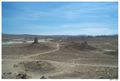 Pinnacles National Natural Landmark |
Kelso Sand Dunes |
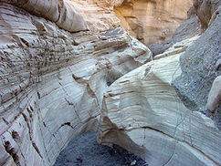
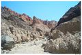 Slot Canyon in Afton Canyon |
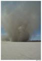 Dust Devil, El Mirage Dry Lake |
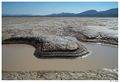 Water hole, Coyote Dry Lake |
Rainbow Canyon, near the city of Barstow |
 Amboy Crater |
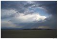 Summer Storm |
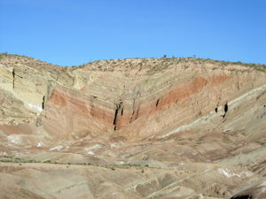 Rainbow Basin Syncline in Barstow Formation near Barstow, California. |
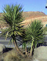 Yucca plant. |
Just south of Highway 95 |
Just south of highway 95 in the Mojave Desert lies what remains of the Joshua Tree from the album of the same name by the band U2. The tree fell in the winter of 1999-2000 |
 Noonday Formation in Death Valley National Park |
See also
- Amboy Crater
- Calico Early Man Site
- Coso Rock Art District
- Clinoptilolite
- Lake Dolores
- List of California regions
- Shrub-steppe
- Mojave Road
- Nipton, California
- Palen Mountains
- Solar power plants in the Mojave Desert
- Zzyzx, California
References
- ã Munro, P et al. A Mojave Dictionary Los Angeles: UCLA, 1992
- ã David K. Lynch. "Land Below Sea Level". Geology.com. http://geology.com/below-sea-level/. Retrieved 2010-04-26.
- ã Mazzucchelli, Vincent G., 1967,"The Southern Limits of the Mohave Desert, California," The California Geographer, VIII: 127-133. This study provides original maps of the Mohave and adjacent deserts in the southwestern states.
- ã "Bryophytes From the Northern Mojave Desert". Bryophytes of Nevada On-line. http://heritage.nv.gov/mosses/mojavems.htm. Retrieved 2010-04-26.
- ã "Hoover Dam". General Contractor Bob Moore Construction Company. http://www.constructioncompany.com/historic-construction-projects/hoover-dam/. Retrieved 2010-04-26.
- ã Rick Reublein, "America's first great woman popular song composer" site.
- ã "Desert Lawsuit Settlement". California Desert District. Bureau of Land Management. April 27, 2007. http://www.blm.gov/ca/st/en/fo/cdd/lawsuit.html. Retrieved 2010-01-12.
a. "Order Re: Defendants' motion to alter or amend the judgment and plaintiffs' motion for injunctive relief" (pdf). United States District Court for the Northern District of California. December 20, 2004. http://www.blm.gov/pgdata/etc/medialib//blm/ca/pdf/pdfs/caso_pdfs.Par.ba8f28ba.File.pdf/Ilston.ruling.12.30.04.pdf. Retrieved 2010-01-12. - ã 8.0 8.1 Mojaveãs Off-Highway Roads Found Illegal
- ã 9.0 9.1 Judge rejects federal plan for SoCal desert routes
- ã 10.0 10.1 10.2 Judge rejects U.S. management plan for California desert
- ã Michael G. Barbour, William Dwight Billings (2000) North American Terrestrial Vegetation, Cambridge University Press, 708 pp ISBN 0521559863
- ã 12.0 12.1 12.2 John Annerino (1999) Canyoneering: How to Explore the Canyons of the Great Southwest, Stackpole Books, 154 pp ISBN 0811727009
- ã C.Michael Hogan (2008) "Western poison-oak: Toxicodendron diversilobum", GlobalTwitcher, ed. Nicklas StrûÑmberg
External links
- Mojave Desert images at bioimages.vanderbilt.edu
- Mojave Desert Blog
- Mojave Desert Catalog Project
- Mojave Desert - Hesperia
Further reading
- Miller, D.M. and Amoroso, L. (2007). Preliminary surficial geology of the Dove Spring off-highway vehicle open area, Mojave Desert, California [U.S. Geological Survey Open-File Report 2006-1265]. Reston, VA: U.S. Department of the Interior, U.S. Geological Survey.
- Mojave Desert Wildflowers, Jon Mark Stewart, 1998, pg. iv
|
|||||||||||||||||||||||||||||
|
|||||||||||||||||||||||